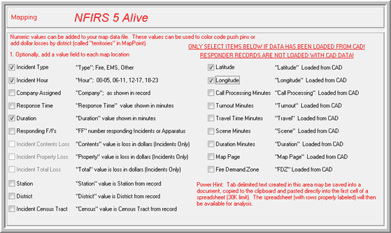
Mapping reports create tab delimited text files for Microsoft Streets & Trips and MapPoint software. Map reports are very easy to define. Every MapPoint text file contains basic location information. You may, however, add information for charting locations by type, dollar loss or other criteria. Just use the check boxes provided to select the additional data elements you wish to be included in the report.
NFIRS 5 Alive now allows you to optionally segregate mapping files by any criteria you choose. Press the "Next" button to view this option.
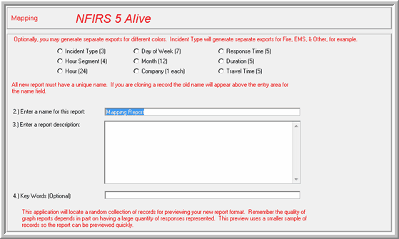
There are nine options for segregating each export. For example, if you select "Incident Type (3)" above NFIRS 5 Alive will create three files, "Fire", "EMS" and "Other" for the records in selection at the time the report was created.
Mapping files are so easy to create you may wish to use this fast create procedure:
1. Select the function button for Incidents, Apparatus, etc.
2. Select the records you wish to place on the map.
3. Press the "Reports" button.
4. Press the "Mapping File" button in the upper left corner.
5. Press the buttons to create the mapping file you wish.
6. Press "Accept" to place the mapping files in the Map folder.
Note: The accuracy of the map points is dependent on the accuracy of the location information entered into the NFIRS 5 report. If your mapping results are not satisfactory consider importing the map text into an Microsoft Excel spreadsheet to correct or update address information. The text can then be linked back to MapPoint via the Excel / MapPoint linking options provided in Microsoft Office. This will allow you more control over the mapping process.
Note: Not all address will geocode. Our tests indicate lower-level mapping software tends to plot between 70% and 85% of the addresses entered. Your results will vary. Make sure you consider this when interpreting any maps you create.