Introduction
Geocoding is the assignment of a latitude and a longitude to an address. Today, many CAD systems automatically track incident locations by latitude / longitude coordinates. If this data is available it's a good idea to import it with your CAD data. If geocodes are not available from your CAD or RMS system most addresses can be geocoded using "web services".
Since geocodes provide a numeric description of an incident's location mathematical formulas may be applied to identify trends geographically. Many of the powerful reports NFIRS 5 Alive sends to graphs may now be directed to maps as well.
Geocoding Overview
Chances are your fire department already has geocoded the location of its fire stations. If so, press the Jurisdiction button and then press the Stations button. Enter the geocodes for each fire station.
If your fire stations do not appear on the list go to Chapter 8 and review the procedure for running a Jurisdictional profile. Running the profile will produce a list of stations with station statistics.
If fire station locations have not been geocoded use the same procedure to geocode stations as described below for incidents. Here's how NFIRS 5 Alive assists with geocoding.
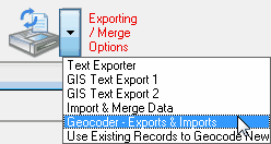
In the Incidents module select "Geocoder - Exports & Imports" under the Exporting / Merge Options button.

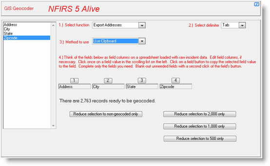
The first step is to export incident addresses. Here's we've selected "Export Addresses" to be separated by a tab character and delivered to the clipboard. We've set-up the field order by clicking on Address and then clicking on the "1" button, clicking on City and then clicking on the "2" button, etc.
We can then select 500 records to geocode by pressing the "Reduce selection to 500 only" button.

Research web sites that provide geocoding web services. Many are free for certain types of use. Others charge a small fee. Most will accept some variation of an address input using Address, City, State, Zipcode in a tab or comma delimited format.
Once a web service processes geocodes it will return the original fields of data with two addtional fields added to each "row" of data. The added fields are latitude and longitude. When you have the geocoded text from a web service simply select "Import Addresses" in #1 above. Then select the position of the latitude and longitude in the data you are importing.
NFIRS 5 Alive is pretty sophisticated about the way it handles geocodes. When you export addresses only unique addresses are exported. So regardless of whether or not an address is repeated in selected Incident records, it's only exported once. Another feature is that one address will be used to geocode not only all occurrences of that address in Incidents, but it will also geocode all occurrences of the address in Apparatus and Risks as well.